After a leisurely start to the morning, I headed out to Sublime Point just before 11am. It was a picture perfect Autumn day in the mountains, with clear skies and sunshine. I wanted to revisit the western section of the Lindeman Pass, between Sublime Point and Leura Falls. My first trip was on a cool and misty day about a year ago, and I had immediately fallen in love with this beautiful track.

The route into the valley from Sublime Point is called Copeland Pass. It begins in a somewhat unlikely fashion, dropping down from the tourist bridge just before the lookout. The footpad is well-worn by climber’s feet as it descends through groves of casuarinas and stunted trees drooping with lichen.

I love making the transition from a popular and well-marked tourist track (this one is even concreted) to a much less visited route. You can be only a few metres away when suddenly it feels like a million miles. The people noises fade away and the smells, sounds and sights of the bush intensify.
The descent of Copeland Pass could be described as a steep scramble. I gather the upper section is mostly used as an access route for climbers. And for anyone who has done a bit of rockclimbing it’s not at all daunting, but for less experienced walkers it could pose quite a challenge, with both the exposure and the series of small drops to negotiate.

There are three drops with fixed ropes. The first two are fairly trivial, with the rope mostly for reassurance, but the third is a little more exposed and would be trickier without the rungs bolted to the rock.

It was the fourth little drop where I almost came unstuck though. This one doesn’t have a fixed rope and is only a small scramble, but I felt a bit unbalanced with my backpack on and thought I’d gently drop it down first. Instead of landing neatly where I’d intended, it started rolling down the hill, gradually gaining momentum as it went. I watched from the top with a horrible, sinking feeling, unable to do anything at all. Luckily there were enough bushes to stop its flight, but as I hopped down to collect my pack I definitely felt like I’d learned my lesson!
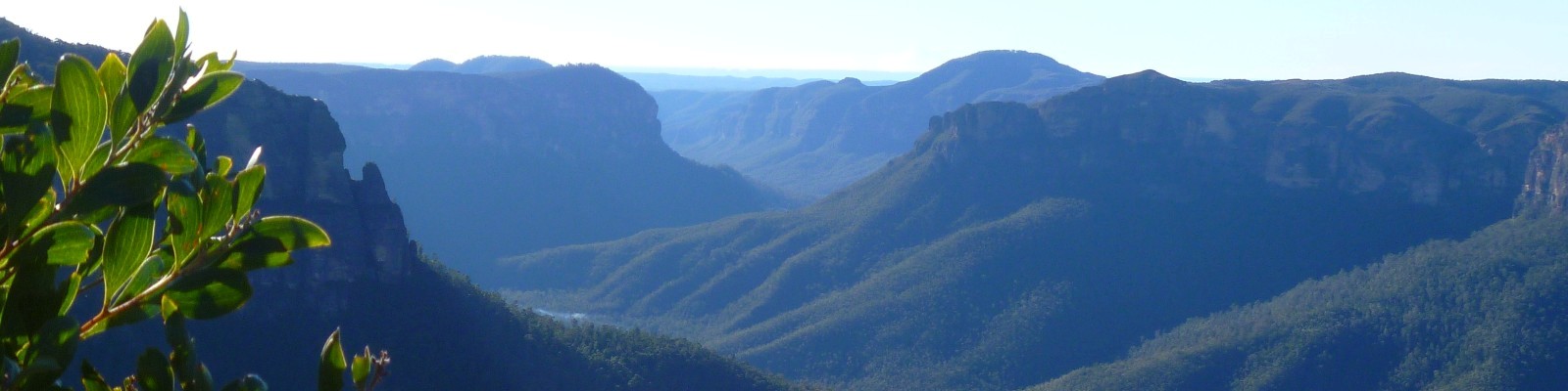
On reaching a small saddle, there is a option of possible routes through the lower cliffline. I chose the easiest of them – the route which goes down the western side of the point – but first I climbed up to a rocky outcrop for some great views of Mt Solitary.

After arriving at a large overhang which marks the climbers’ ledge, the pass heads down a small gully to the left. The thick carpet of leaves and casuarina needles is quite slippery and requires concentration and careful footing to avoid a mishap. Eventually, when this gully becomes too steep to negotiate, there is a faint track that traverses around to the right. The next gully over has a more gentle gradient.
I was about an hour from the top and only a few metres shy of the Lindeman Pass when I slipped and fell on some loose ground. At first I thought I may have twisted my ankle, but after sitting for a few moments and then tentatively putting weight on it I was thankfully without any pain. Phew!

On my first trip down this way, I was unsure how obvious the Lindeman Pass would be and was mildly concerned that we would descend too far and miss the track. But I needn’t have worried as this section of the pass is in great condition and is a lovely, flat trail through open forest.

On another trip I had tried to find the route up Copeland Pass from the bottom and was unable to locate the western pass. The start of the route is not all that obvious (no track as such) but it is well-marked with a large cairn, so on hindsight I think I must have turned around too early that time.
The walking now becomes very gentle and easy. There are occasional logs across the track, but these are a rarity. I kept my eye out for fungi, but with such warm, dry weather lately I didn’t find a lot.


My first inkling that something was amiss was when I reached Lindeman Falls and found some ugly, bright pink arrows painted on the rock, indicating the (fairly obvious) route across the bottom of the falls. These graffitied markings unfortunately became more frequent as I continued on, and correspondingly I became more and more despondent at the willful desecration of this beautiful place.


Shortly after Lindeman Falls the track reaches Gordon Falls. This is a lovely rainforest section where I decided to stop for some lunch and a short break. The track passes behind these falls on a narrow ledge, which is a real highlight of the walk. It’s quite magical to watch the veil of water streaming down, framed by ferns and the deep green of rainforest leaves.


There are a few muddy sections as the track winds its way past a number of other small waterfalls, and also some magnificent ledges offering views into the Jamison Valley.

To my shock and disappointment, the pink fluoro arrows were everywhere over the final section of the walk, splashed across rocks and coachwood trees with indiscretion. Often they were in places where the track is perfectly obvious, e.g. following below a cliffline where there is literally nowhere else you could possibly walk. The worst part was just on the western side of Leura Falls where the track is more indistinct, although the forest is quite open and it would be very hard to get lost.


I can understand people wanting to blaze the trail in sections where it has been damaged by landslide or fallen trees and has become confusing, and doing so with metal markers or removable tape (which has proliferated in recent years) is fine. But the blatant vandalism I witnessed today is appalling.

Soon I was back on the tourist track, and climbed through the fallen trees which had landed on the bridge below Linda Falls. It was a pleasant climb up through Fern Bower to Leura Cascades. Here I met the Prince Henry Cliff Walk and started meandering back towards Sublime Point.

It was lovely to feel unrushed. Most of the time when I head out for a walk I’m very conscious of needing to be back within a certain timeframe, usually so I can look after the children. But with my family away up the coast, I enjoyed the mental freedom of allowing myself to linger a little more than usual.

Although I’ve walked the cliff-top track many times, I don’t think I’ve ever detoured to Bridal Veil View lookout before. This was a bit of an oversight, as it’s a rather spectacular vantage point. I’d like to come back after heavy rain to witness the falls in their full glory. I was also impressed by Tarpeian Rock – another spot that had escaped my knowledge previously. It looked like a beautiful setting for an afternoon picnic.

As the afternoon light began to really glow, I continued around to the top of Gordon Falls, then via the Pool of Siloam and up to the Golf Links track. This is an undulating track with fine views across the hanging swamp and into the Jamison Valley. The three sisters can be seen clearly from here too.


The final 20 minutes of my walk took me behind the houses on Sublime Point Road and past a small memorial to the late Gary Tweddle, who became lost in the bush near here during the winter of 2013. His mysterious late-night disappearance instigated the largest search ever conducted in the Blue Mountains, but sadly his body was found six weeks later.

Six hours after starting out, I returned to Sublime Point lookout to find it bathed in golden afternoon light. All in all it was a glorious day’s walk, but marred by the damage that’s been done to this special place. Given there was no graffiti on Copeland Pass, I’m fairly certain the vandals would have continued around to Gladstone or maybe Roberts Pass. The thought of this makes me feel sick inside and I’m not sure I have the fortitude to explore just now and take stocktake of any additional damage.
I have spoken with National Parks and will wait to hear how they intend to respond.
I like the bit about the runaway backpack!
What lovely photos and notes Jo – thanks so much for sharing. What a shame about those arrows though 🙁 – someone had mentioned them to me the other day and I couldn’t quite believe it. I know that a LOT of people get lost down there and now that the track has been printed on the updated Katoomba toppo, maybe more will head down that way. Thanks again Jo!
Thank you Caro! Yes, it was absolutely devastating to see so much graffiti in such a beautiful little pocket of the Jamison Valley. It’s interesting to hear that it’s been marked on the new topo! On the one hand it’s nice to see it finally getting the recognition it deserves, but it could prove to be a nightmare for search and rescue teams if people are expecting a tourist track. I didn’t realise it was already such a problem! Thanks again for stopping by and for your warm encouragement of my little blog.