This walk was the culmination of many hours spent exploring the bush tracks to the north and west of my home in Wentworth Falls. My first goal had been to find an easy way across Wentworth Creek and up to Mt Hay Road. But then I discovered the track down to Henson Glen and started reading about the historic Bruce’s Walk. The final piece of the puzzle fell into place when I found the track across Katoomba Creek. Today was my first attempt at linking it all together.

I headed off early, with that lovely feeling you get from walking straight out the front door instead of hopping in the car. There was a bit of fog hanging around in the valley and overcast skies, but no imminent threat of rain. Suburbia quickly fell away as I passed the last couple of bush blocks before making my way down towards the creek. There are signs here indicating that this area falls within the danger zone for the Leura Rifle Range, but by passing through so early in the morning I was assured a safe passage. It has certainly deterred me from further exploration of this area though.
This section of Wentworth Creek is rather lovely, with tall stands of white-trunked eucalypts – I wish I knew what they were! After crossing the makeshift bridge of logs and passing a small but very sheltered camp cave on the far side, the track ascends steeply up towards Mt Hay Road. Whenever I’ve walked along here, it always seems as though the track has been freshly mown. Is there someone who brings a brushcutter down here regularly? If not for these efforts, I think the track would be quickly swallowed up by the swampy heath vegetation.

Bruce’s walk was originally built in 1931 as a maintenance track for workers to access the new transmission line between Blackheath and Lawson. It was subsequently advertised as a tourist route, but then abandoned during the war years and all but forgotten. A group of committed volunteers spent much time during the 1980’s clearing the track and rediscovering the original formations, but large sections of it have now been bulldozed and replaced with vehicular access roads.
About an hour after I started, I found myself on Mt Hay Road and walked the short distance down to where the power lines cross the road. The next section is unfortunately one of the ugliest parts of the walk, following the wide, gravelly scar of the access road.

The hanging swamp that filters down to a small waterfall here has a sad, abandoned feel, and has suggested to me (perhaps erroneously) that this was once a site of Aboriginal significance.

At the point where the fire trail crosses beneath the power lines and heads north to Henson Glen, there is a foot track that zigzags down into Govetts Creek. I have always just waded across the stream here previously, but with so many kilometres ahead of me I spent the extra few minutes searching downstream to find a crossing that would keep my feet nice and dry.

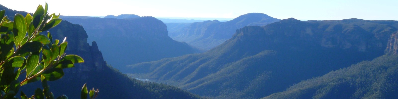
In spring these swampy heathlands are alive with wildflowers, but at this time of year they are more subdued – it is mostly the banksias that add a splash of colour. The footpad on the west side of Govetts Creek soon joins another steep, rocky access road that heads up the hill. From the top of Minnehaha ridge I looked back to the south-east and could trace my route from all the way from Mt Hay Road.

I have described elsewhere my joy at locating the next section of Bruce’s Walk, which enables an easy crossing of Katoomba Creek. Again, I felt a strong pull to explore both upstream and downstream of this crossing point. It’s a beautiful stretch of creek, lined with king ferns and numerous sandy beaches. But today my journey lay straight ahead, through the thick ferns and up to the airfield.

I reached the fire trail near Katoomba airfield about three hours after leaving home, and spent another half an hour walking along dirt roads to get to the start of the Pilcher Track. This is a favourite little track of mine, with gentle gradients, pleasant views and a dramatic descent into Greaves Creek.

After several hours spent walking through dry schlerophyll forests, open heath and swamps, it really felt like I had entered another world when I descended into the Grand Canyon. The main loop track through the canyon has been closed since last October, so the track was much quieter than usual for a Sunday. It’s quite a magical place, and one of the few spots where you can experience the atmosphere of a Blue Mountains sandstone canyon while remaining on a superbly crafted tourist track.

My legs were starting to feel weary as I headed up to Evans Lookout. After four hours without seeing another soul, I started to meet a few people coming the other way. By the time I slowly reached the top, the cloud was really rolling in and the views were mostly obscured. All that remained was to follow the Cliff Top and Braeside Tracks back to the village. By this stage I was looking forward to a good rest and pushed myself quite hard to get to Bianca’s place in time for lunch.

I was welcomed inside and showered with yummy food and cake, before generously being offered a lift home. I had planned to catch the train, but it was rather lovely to sit in a warm car for 20 minutes instead of waiting on a cold train platform. My body had gone into slight shock, and I was starting to feel very cold. But it was hugely satisfying to reflect on my achievement of navigating and negotiating my way through this little-visited stretch of bush, entirely under my own steam, to complete a journey that at one time I would not have thought possible.
What a wonderful journey (and it must have been nice to arrive in time for lunch!)
Indeed it was! It always tastes so much better after a hard walk too 🙂
Congratulations Jo! Fantastic effort to complete your much anticipated walk. Looking forward to sharing it with you one day xx
Thanks Kaz! It was such a thrill for me to complete this, even if it’s not the most beautiful of walks. There’s nothing like trying something new, is there?
Great account, Jo. Being a WF resident myself I’m working up to beginning my own exploration of Bruce’s Walk with my lockdown walking buddy, Steve.
The tall white gums in your first photo are eucalyptus oreades, also known as Blue Mountains Ash. They love the high gullies and cliff edges of the Blue Mountains most of all though they occur in patches from Mittagong to SE Queensland.
Hi Peter. Thanks so much for reaching out and sharing your knowledge about the eucalypts! I should have guessed they were oreades… beautiful trees. The blog has been dormant for a long time, but I’m just back from a walking trip in Tassie, so hope to update it soon.
How did you go with your lockdown exploring of Bruce’s Walk? I hope it was an enjoyable distraction.
I stumbled upon this track the other day (just across Blaxland Rd from my house) and ventured down to the first creek crossing. I was only wearing clogs and jeans, so wasn’t properly equipped for a real adventure, but I can’t wait to follow in your footsteps in the very near future!
Thanks for the write up. It gives me the confidence to cross the creek and venture further down the track.