The crossing of Katoomba Creek had been a goal for some time. It was the missing link in my exploration of the western part of the historic Bruce’s Walk. This time I started from the end of Minnehaha Road and headed down the track towards the falls. Before long I took a fire trail off to the right and onto the ridge between Katoomba and Govetts creeks.

I’ve been exploring short sections of this track as time permits, and over a number of previous trips had made it from Wentworth Falls to North Katoomba. But my earlier attempt at getting down to Katoomba Creek had been thwarted when the track started to descend more steeply than I liked, and looked as though it was heading for the edge of a cliff.

Bruce’s Walk is not shown on the Katoomba topographic map, but after studying various other maps and aerial photos I suddenly realised last night where I had previously gone wrong. Sure enough, when I got to the point where the track starts to descend steeply, I noticed a small cairn and an indistinct track heading off to the left. I’m not sure how I missed this last time, I must have been in too much of a rush.
This part of the track is a bit overgrown, but relatively easy to follow as it zigzags down to the creek. About halfway down there are some interesting rock pagodas and the track descends through a narrow break in the cliffline. There are good views of the upstream section of the gorge. The last few metres down to the creek are a bit muddy and slippery, and overgrown with thick ferns, but by this stage the creek is in sight so you know it’s not far to go.

At the point where the track crosses, a long pool extends upstream. It might be a nice summer trip to wade, swim and splash upstream to Minnehaha falls, but it’s probably quite scrubby in places too. Being midwinter I was keen to avoid the water, and was glad to hop across the rocks. It was getting late in the afternoon so this was a bit of a decision point for me. Prudence suggested I should turn around here and head back to the car, but my curiosity won out instead. I was keen to see what the track was like on the other side of the creek, and how easy the access is from Medlow Bath.

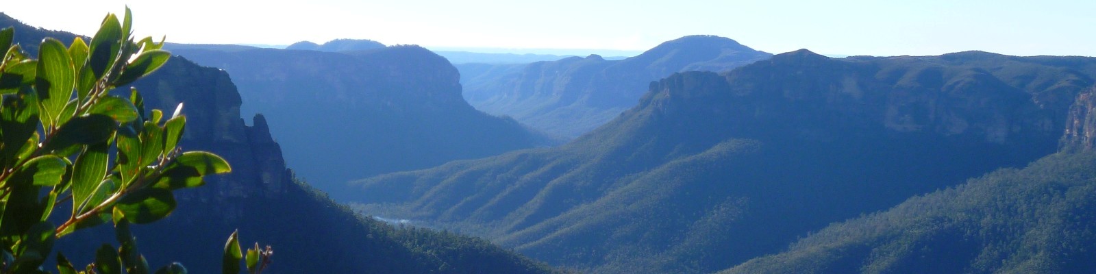
So I headed up through ferns and tall, young eucalypts, then finally to the low-lying heath vegetation high above the creek. Again, there were nice views looking upstream into the gorge. This sprengelia, or pink swamp heath, was looking very lovely. It’s not a plant I have really noticed before.

There were a few small scrambles on the western side of the creek and some roughly hewn stone steps. There is also quite a bit of old hand railing, although in places just the supports and not the railing remain. I’m guessing this would have been a more popular section of the walk and that the steeper gorge necessitated more elaborate track building than elsewhere. I have not seen any infrastructure on other parts of the walk as yet.
On reaching the fire trail I turned right and continued on to the hill at the end of the road, hoping for some good views down into the valley. The views were not particularly impressive but there are some lovely stands of scribbly gums, and another track that descends steeply to the creek at this point.

Bruce’s Walk was originally constructed in 1931 to provide maintenance workers with access to the transmission lines that had recently been built in the vicinity. It was suggested that this walking track could be turned into a scenic attraction, and it was subsequently advertised with a large, colour brochure and map. However, with the coming of the war it no longer received any maintenance, and slowly fell into obscurity.
I was pleased to see that Bruce’s Walk is reasonably obvious from the western side of Katoomba Creek. This painted rock is only a short distance from the trailhead, which is further marked with cairns on either side.

After calling for a lift, I was met at Katoomba Airfield by my family, and we continued out to Point Pilcher to watch the sun set over the Grose Valley on the shortest day of the year. The skies had been quite drab and overcast during my walk, but had cleared somewhat just before sunset. Fortress Ridge and Banks Wall were bathed in glorious rich colours from the low, golden sun.

While much of Bruce’s Walk is now spoilt by ugly fire trails and maintenance tracks, there are some lovely creek crossings and beautiful little glens in parts of the national park that would otherwise get very little visitation. The final western section of Bruce’s Walk between Medlow Bath and Blackheath is no longer possible due to the exclusion zone around Lake Greaves and that fact that part of the original track was submerged when the dam was built. However the Pilcher Track starts from quite nearby and is a very beautiful alternative.

I’m quite excited to think that I can now walk from Wentworth Falls to Blackheath, through bushland virtually all the way, and it would probably only take me about five hours! I might have to try that next time we’re invited to dinner in the Heath.
Thanks for such inspiring posts, I’ve been a bit slow in reading the earlier ones but now I can’t wait for the next instalment. I also look forward to joining you all on a walk or two on our next trip to the mountains. You live in such a special part of the world and your posts make it magical.
Aww, thanks so much Dad! I enjoy being able to share these special places with you virtually, but look forward even more to doing some walks together next time you’re down this way xx
Hi Jo, thank you for sharing your amazing experiences of walking from Wentworth Falls to Blackheath. I was particularly interested in your description of Bruce’s Walk as I live in North Katoomba and have attempted part of the walk, exploring the surrounds of Katoomba Creek. I co-ordinate a neighbourhood newsletter here in North Katoomba and would like to include some of the exploration you have described here for our locals. Would it be possible to include excerpts from your account here? You can contact me directly for more information if you wish….
Hi Caroline, thanks for your message and lovely to hear that you’ve been out exploring too! I’m happy for you to share some of my account, with the caveat that this was written seven years ago. I haven’t been out that way recently, so I’m not sure what state the tracks are in after the sustained wet weather we’ve had over the last couple of years. Might be a bit more difficult/dangerous to navigate than it was previously.
I agree Jo, the tracks would certainly be affected by the fires and rains over the last 3-4 years. It would be of interest to bushwalkers to know what less-beaten tracks are currently ‘safe’ between Wentworth Falls & Blackheath. I may look into this further. Your 2015 account through Bruce’s Walk may be a basis for an up-to-date article on bushwalking in this area. Thank you once again for sharing your experience. It has inspired me to get back out there, with extreme caution, and rediscover the wonders in our backyard.
I attempted the route this week. I started at Medlow Baths and followed the road and fire trail past the airfield and then dropped down the steep descent to Katoomba Creek. It was a mild dry day, so not slippery, and I was grateful for a few of the steps which have been put in. But reading some of these posts, I’m now wondering if I dropped down to the Creek in the wrong place.
When at the waterline, it was fairly easy to find a spot to wade across. I took my shoes and socks off, and as long as you’re careful with your footing and mindful of how slippery some of the rocks are, it is a really pleasant spot.
On the opposite side, I struggled to find where to pick the track back up. I got up to the rock level, and transversed left and right to find an obvious ascent point. There were a couple of places where it looked like others had propped up large branches to help clamber up the first sheer sections, but as I was on my own, I didn’t want to take the risk.
Did I cross the Creek at the wrong point? I think maybe I should have dropped down from the airstrip trail earlier and crossed the Creek further upstream.
I’m going to have another try and come at it from the Wentworth Falls side instead. Any tips much appreciated.